Fieldwork: Marrickville
Field sketch
Draw two different field sketches of Marrickville – one that shows evidence of the heritage of the suburb and one that shows evidence of change taking place (this might be more modern architecture, high density housing, etc.). Ensure that you annotate your field sketches.
Environmental survey
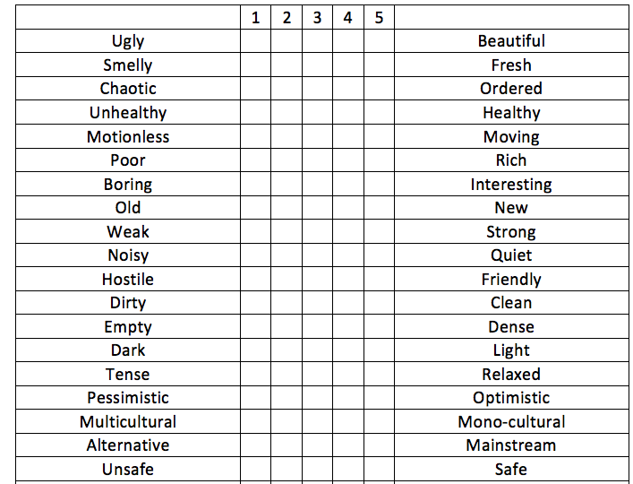
Examine the following environmental criteria and make a judgement about the main street of Marrickville. This is a subjective task and requires you to make a judgement about what you think of the location and how it makes you feel. For each item you need to give a rating from 1 to 5 (tick the box).
Draw two different field sketches of Marrickville – one that shows evidence of the heritage of the suburb and one that shows evidence of change taking place (this might be more modern architecture, high density housing, etc.). Ensure that you annotate your field sketches.
Environmental survey
Examine the following environmental criteria and make a judgement about the main street of Marrickville. This is a subjective task and requires you to make a judgement about what you think of the location and how it makes you feel. For each item you need to give a rating from 1 to 5 (tick the box).
Photographic evidence
During the day, take photographs that demonstrate:
- Marrickville’s heritage
- Multiculturalism
- Marrickville’s industrial landuse
- Marrickville’s artistic scene
- Marrickville’s alternate culture
- Marrickville’s café culture/pub scene
Land use survey
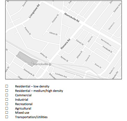
A land use survey is a study and recording of the way in which land is being used in an area; usually classified as commercial, industrial, public, residential, etc. As you walk along the streets annotate your map indicating which land uses are present. Before you begin, fill in the key below with colours or symbols to represent each land use (yellow – low density residential, brown – high density residential, red – commercial, grey - industrial, blue – public facilities/institutions, green – recreation). Compare your landuse survey to the proposed plans for Marrickville and describe the landuse changes that will take place.
Reflection:
Describe how the different land uses are represented in discrete zones in the suburb of Marrickville.
Explain why the commercial and industrial land uses are concentrated in particular areas.
Download the Fieldwork - Marrickville file here:
Describe how the different land uses are represented in discrete zones in the suburb of Marrickville.
Explain why the commercial and industrial land uses are concentrated in particular areas.
Download the Fieldwork - Marrickville file here:
| fieldwork_-_marrickville.docx |
| what_is_a_land_use_survey_.doc |
